egg Hunt- using GPS Units with 1st and 2nd graders
This week I decided to do a class egg hunt. How could I add a twist to it. My students are quick learners. I prepared eggs with different locations and different rewards at each of the 4 locations.
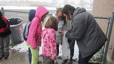
After preparing all the eggs and deciding how I would run it. I hung 7 GPS units around my neck. I walked to each location and marked the waypoints. I named each each point on each f the GPS Unit. I tried to make it as simple as possible.
The kids did great. I'm really pleased with the excitement of the lesson and activity. The Pros: Students worked well together. They had a great time. Didn't take too much time.
Con's: Put in smaller groups, all the kids want to touch the device.
Look at the weather before planning an even like this. ( It snowed all day. Everything was buried.) They still had a great time. Prepare waypoints on an extra GPS in case batteries die.
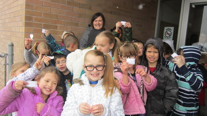
Students brought their final clue to me for a classroom reward. ( Lunch with a friend, 20 minutes i-Pad time, shoes off for day, a few other certificates.)
They had a blast.
CMaP Project _ Where is all the trash?
Here is a project I would like to take back to my school and use to implement the GPS/ GIS into my classroom. We have a ton of litter after football and soccer teams leave our school. Where can we put trash cans to reduce litter at Bell View Elementary?
Little Cottonwood Canyon Watershed
6/14/12
Today in class we used a GPS and took 5 way points along Little Cottonwood into the Jordan River. I waded in 40 degree water taking water samples testing for PH, water quality (dissolved oxygen), nitrates, water temperature, turbidity (clarity of water) and looked for bugs. After gathering all of my data I entered my information into and excel file (.csv) and created a table to be displayed in ArcGIS. I have included a few pictures that were taken and uploaded to Dropbox, also I have included my map from ArcGIS and the .csv file that I created. Overall, this is a great tool that can be used in my classroom for my CMaP project. I learned that gathering my own data really helped me own this project. I loved see my data turn into a map.

Tree Activity
Here is a map of my tree data. This was really interesting and a fun way to display our data. I enjoyed taking our data and putting it in excel or a .csv file. I have never done that before. Then we imported 4 layers and merged them to show all of our data. :) This looked really neat in ArcGis.
Click to set custom HTML
View Larger Map
View Larger Map
